If you love fox hunting – you’ll probably love radiosondes
Radio Technology Meets Meteorology: A Deep Dive into Radiosondes
Radiosondes provide an exciting opportunity for amateur radio operators to combine their passion for radio technology with meteorology. Think of it like combining geocaching and fox hunting into one fun activity! We’ll delve into what radiosondes are, why they’re important, how you can track them using radio equipment, and even explore how to use SondeHub – a popular radiosonde tracking website.
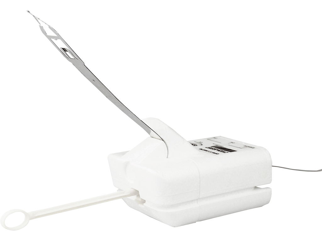
DFM17 Radiosonde
The DFM17 is a radiosonde manufactured by GRAW. This is a common radiosonde used by the National Weather Service and is one of the smallest and lightest radiosondes on the market today.
What Does a Radiosonde Launch Look Like?
How to use SondeHub
SondeHub is a collaborative platform dedicated to tracking and sharing data from weather balloons, also known as radiosondes. On SondeHub, enthusiasts and professionals alike can contribute to and access this wealth of information. By using interactive maps and tracking tools, users can follow the real-time or historical paths of these balloons, analyze the data they gather, and even contribute to the recovery of the sondes after they land. SondeHub can help you:
- Find predictions where radiosondes will fly (and land) for the next seven days based on weather models.
- Track real-time radiosonde location and landing areas thanks to a network of monitoring stations.
- See historical data on radiosonde flights
- Track amateur radio High Altitude Balloon flights
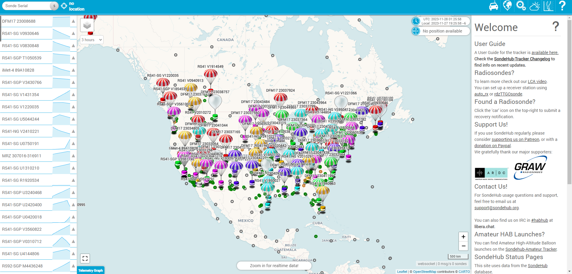
This is the first thing you’ll see when opening SondeHub. It will show a visualization and list of all radiosondes tracked over the last three hours. Remember that radiosondes are launched twice each day. Once in the morning, and again in the late afternoon. On rare occasions the National Weather Service will launch three balloons in a single day during periods of severe weather.

I clicked on a radiosonde icon and can see the flight path of DFM17 23044965. In this photo, it’s currently airborne east of La Crosse, WI. The radiosonde is being heard by the KA0ATU monitoring station in southeast Minnesota. That is what all the green dots represent — monitoring stations that are currently online. It is predicted to land southeast of La Crosse, WI near the green bullsye. All the green dots on this map are listening for radiosonde telemetry on 403.610 MHz.
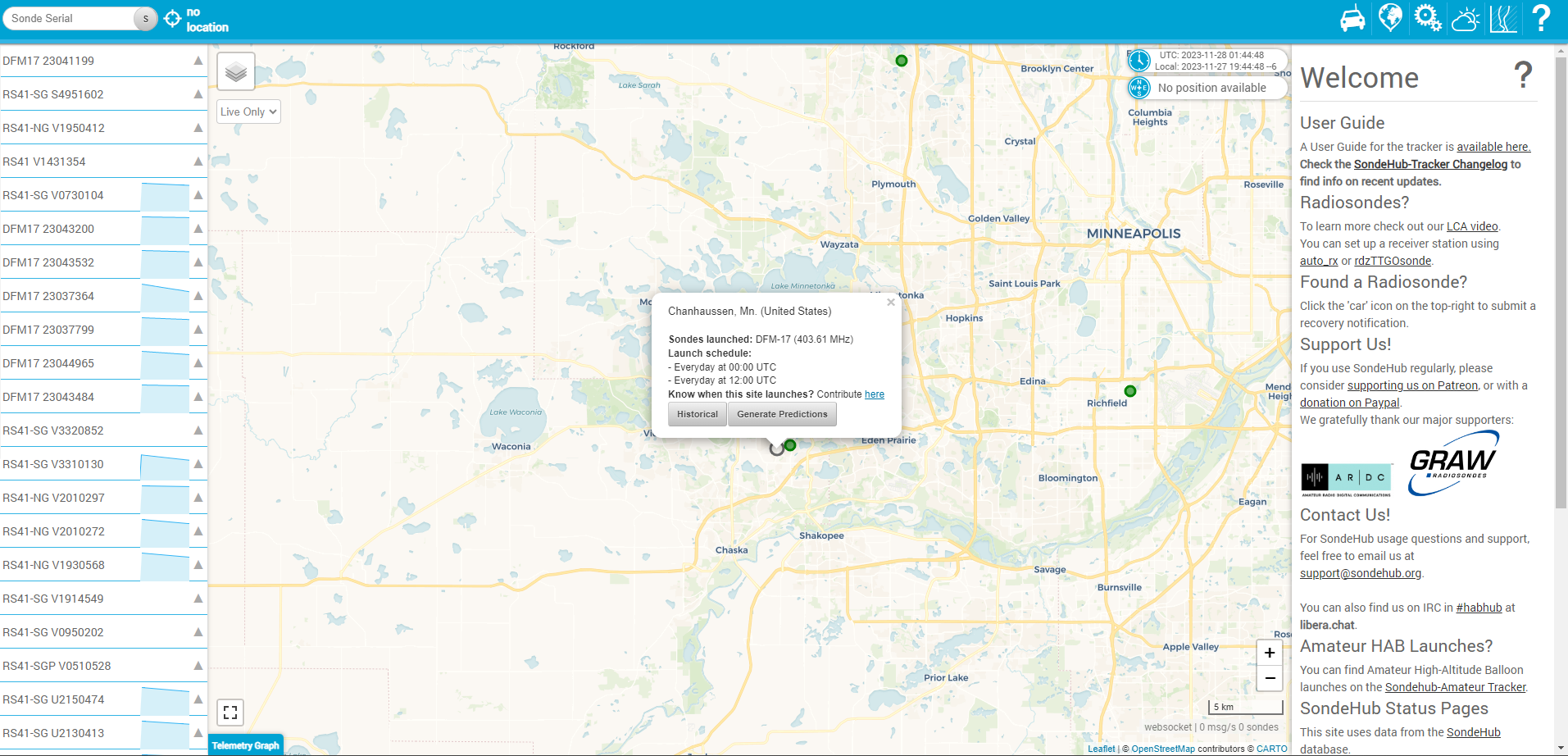
White dots with a grey outline are radiosonde launch sites. Not all NWS offices launch balloons. Clicking on that icon will bring up a menu showing what radiosonde is used, its frequency, and what times balloons are launched. From here you can select ‘Historical’ to access past flight data or ‘Generate Predictions’ to see where balloons may fly/land over the next seven days.
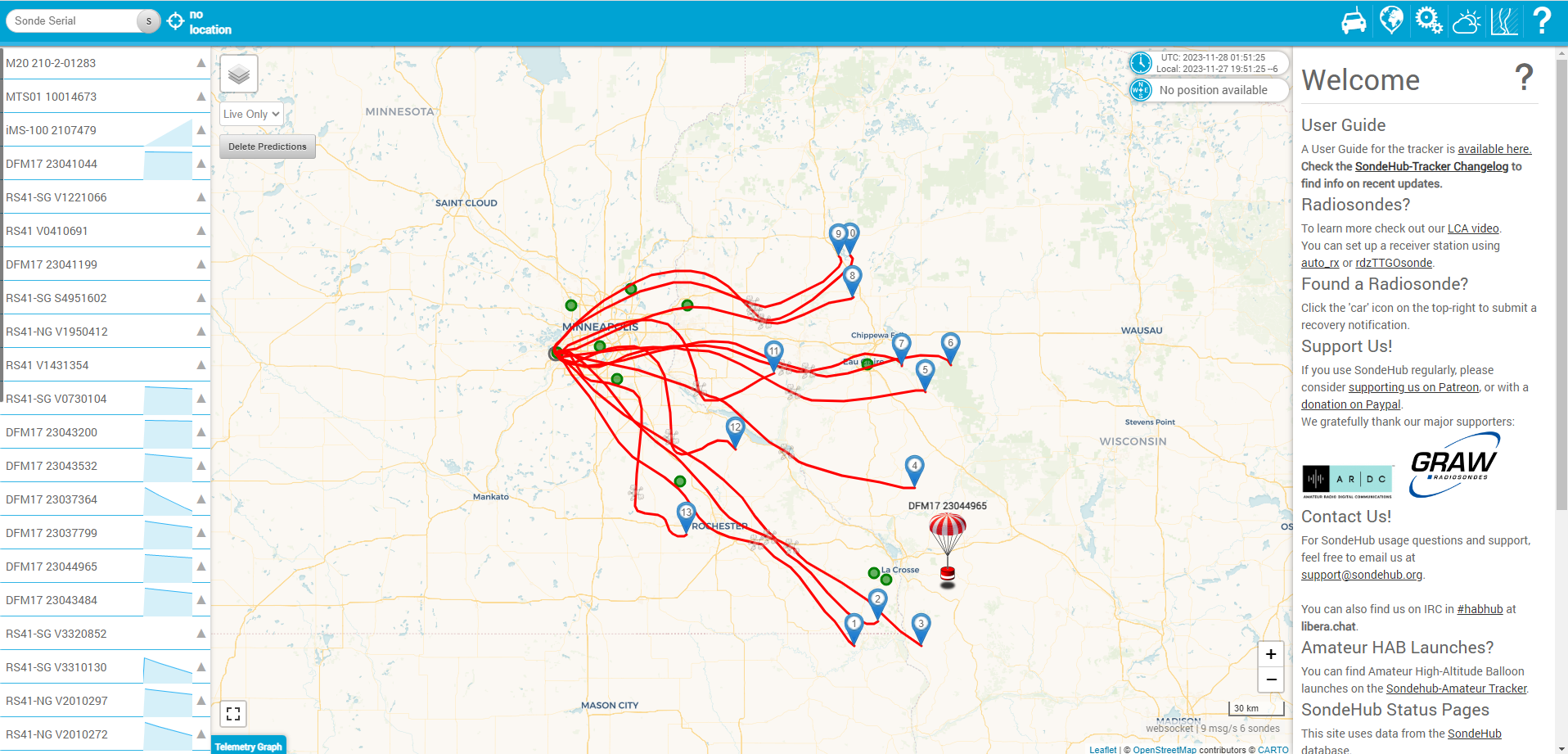
I clicked on ‘Generate Predictions‘. We can see predictions for the next 14 balloon launches from NWS Chanhassen. The lower numbers represent launches coming up sooner, while numbers 13 and 14 would be launches occurring 7 days in the future. There is also a small grey burst icon along the red line. This icon on the flight path indicates where maximum altitude (>100,000 feet) will be reached. Everything between the burst icon and the blue pin will be the radiosonde descending towards earth.
These predictions are just that…predictions. They’re not perfect, especially many days in advance. They’ll improve as the day gets closer, but even then the final landing zone could adjust depending on local weather patterns. The adjustment is typically 5-20 miles, but still worth watching when the balloon is in flight to make sure you’re in the right general area.
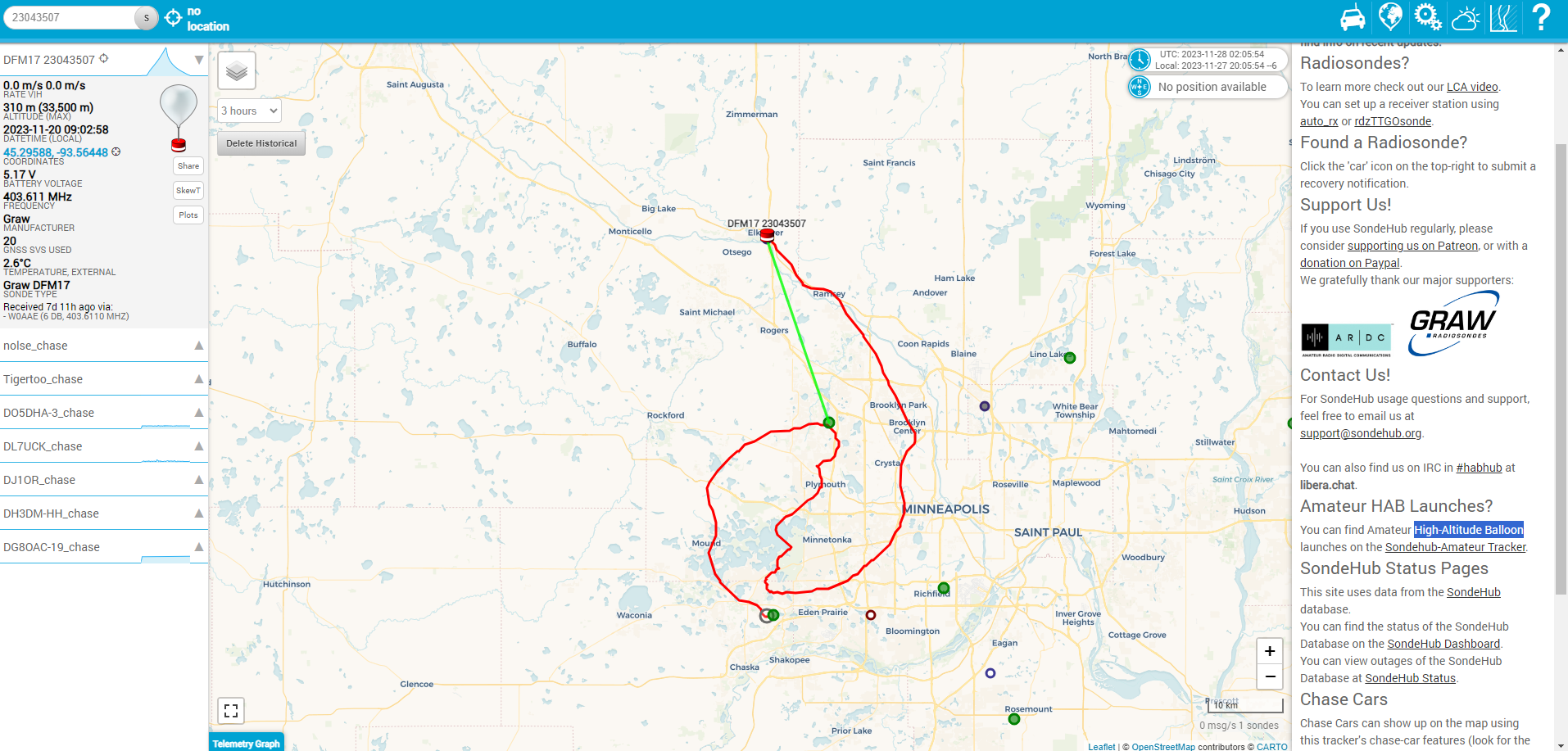
The above photo shows a balloon launch from November of 2023 that I went out to recover. The balloon remained over the west metro before landing in Elk River, MN. It was tracked by multiple monitoring stations, but the last station to track its location was W0AAE in Maple Grove, MN.
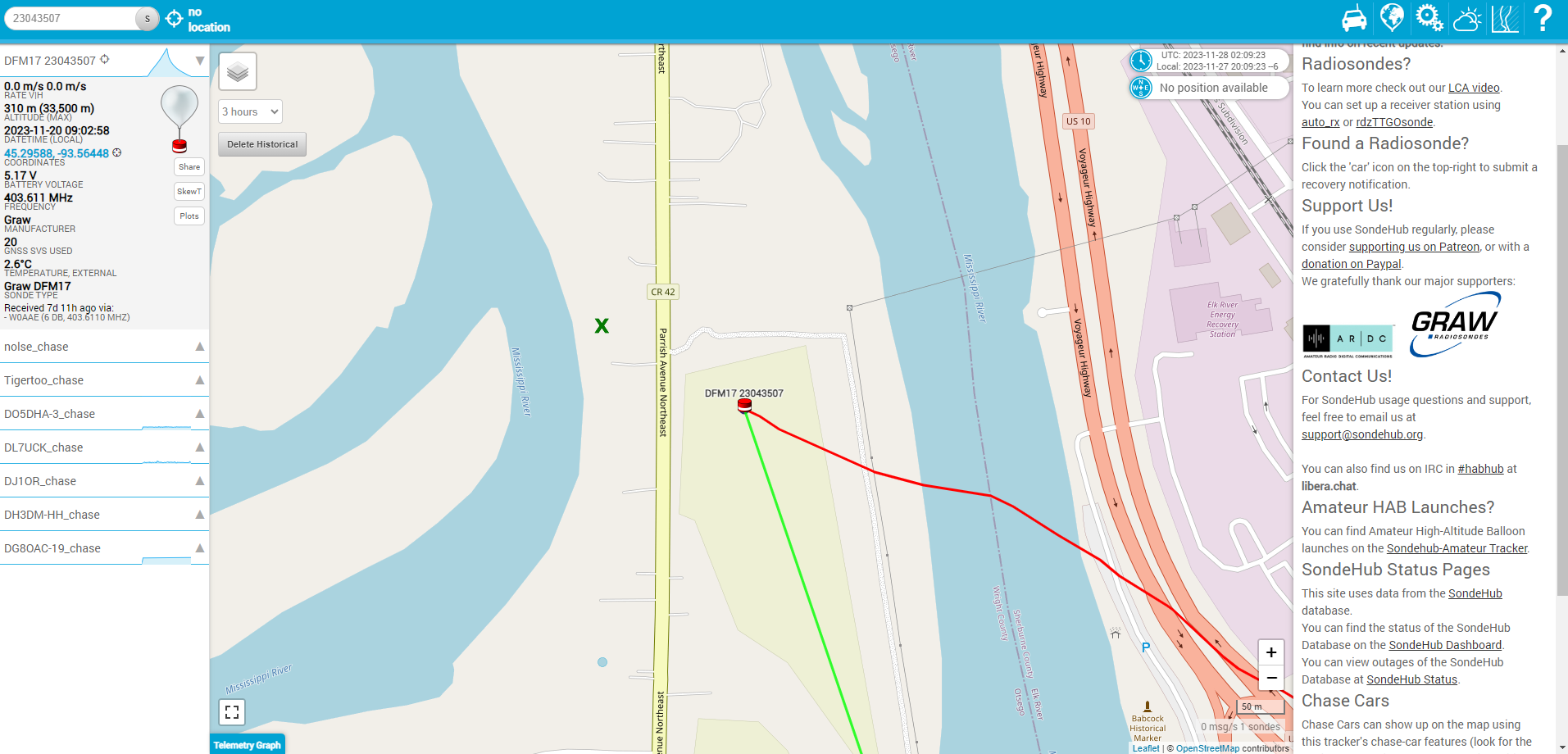
As we zoom closer to the predicted landing area we see the radiosonde was last heard by the W0AAE monitoring station in a farm field just east of Parrish Avenue. However, I found it stuck in a tree about 70 feet high at the ‘X‘ located west of the road. Keep in mind that depending on how close monitoring stations are located and the lower-level winds you’ll likely find radiosondes beyond their last known location. Pay attention to the radiosonde’s descending speed and last heard altitude. The higher the altitude the more variability in its final location compared to the map. Also, note the radiosonde was found in line with its northwesterly flight path. Had it not been for the tall tree it would have landed in the Mississippi River. Use your radiolocation skills to determine its final location by listening for the beacon. It sounds like a constant data transmission with a one-second ‘pining’ embedded in the signal. I submitted my log to SondeHub and declared it was found but not recovered. The more radiosonde listening stations we can get online in Minnesota and Wisconsin the more accurate tracking will be!
Where can we use more monitoring stations
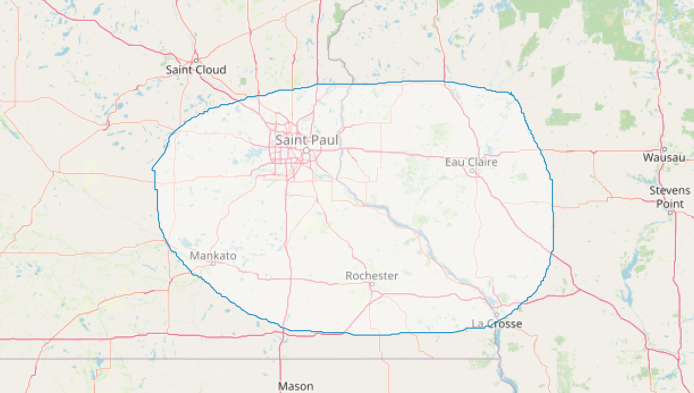
Based on historical data the following polygon shows where we could use more monitoring stations. We have a good amount in the Twin Cities metro – but if you live in southern Minnesota or western Wisconsin you may want to help contribute by operating a radiosonde listening station. They’re easy to build and maintain. Even a simple antenna at 20 feet is helpful, but like any antenna — the higher the better! Here is some helpful information on setting up a monitoring station.
Are you ready to join the fun?
Radiosondes offer amateur radio operators in Minnesota and Wisconsin a unique and rewarding opportunity to explore the intersection of technology and meteorology. By tracking these airborne instruments, you can actively contribute to weather research, improve your radio fox-hunting skills, and gain valuable insights into the ever-changing atmosphere. So, grab your radio equipment, join the radiosonde tracking community, and embark on an exciting journey into the world of atmospheric science and radio technology! Happy tracking, and may your adventures in radiosonde tracking be both educational and exhilarating!
Sondehub User Guide
Check out the SondeHub user guide – the primary online community for tracking and recovering radiosondes across the world. This resource will give you even more details on how to use SondeHub more effectively.
AMATEUR RADIO HIGH-ALTITUDE BALLOON TRACKING
Tracking high-altitude amateur radio balloons around the world. You may even end up decoding balloons passing over the northern United States from your home station.